Forgotten History
Kasteel Zorgvliet (Sint-Katelijne-Waver)
Sint-Katelijne-Waver, Belgium
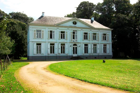
Castle Zorgvliet is a castle in Elzestraat, a town belonging to the Antwerp municipality of Sint-Katelijne-Waver, located at Zorgvliet 15-17. The castle was built shortly before 1854 on land where a farmhouse had previously been located. It is built in a neoclassical style and shows strict symmetry. The front and rear facades are adorned with a triangular pediment.
- Category
- Forgotten History
- Location
- Sint-Katelijne-Waver, Belgium
- Address
- Zorgvliet 15-17, Sint-Katelijne-Waver
- Coordinates
- 51.05504, 4.49126
- How to get there
- Google MapsApple MapsOpenStreetMap
- Wikidata
- Q116170372
What is Kasteel Zorgvliet (Sint-Katelijne-Waver)?
Kasteel Zorgvliet (Sint-Katelijne-Waver) is a Forgotten History place on VeroMaps, on Zorgvliet 15-17. Other places close by: Fort van Sint-Katelijne-Waver, Kasteel Rozenhouthof, Molen van Meeusen, Fort van Walem.
Where is Kasteel Zorgvliet (Sint-Katelijne-Waver)?
Kasteel Zorgvliet (Sint-Katelijne-Waver) is in Sint-Katelijne-Waver, Belgium. Coordinates: 51.05504, 4.49126.
How do I get to Kasteel Zorgvliet (Sint-Katelijne-Waver)?
Kasteel Zorgvliet (Sint-Katelijne-Waver) is at Zorgvliet 15-17, Sint-Katelijne-Waver, Belgium (51.05504, 4.49126). Enter these coordinates in Google Maps, Apple Maps or OpenStreetMap for walking, cycling or driving directions.