Urbex & Abandoned
Mount Weather Emergency Operations Center
Virginia, United States
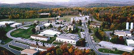
The Mount Weather Emergency Operations Center is a government command facility located near Frogtown, Virginia, used as the center of operations for the Federal Emergency Management Agency (FEMA). Also known as the High Point Special Facility (HPSF), its preferred designation since 1991 is "SF". The facility is a primary relocation site for the highest level of civilian and military officials in the case of a national disaster, playing a significant role in continuity of government (per the U.S. Continuity of Operations Plan). Mount Weather is the location of a control station for the FEMA National Radio System (FNARS), a high frequency radio system connecting most federal public safety agencies and the U.S. military with most of the states. FNARS allows the president to access the Emergency Alert System. The site came into the public eye in 1974 by The Washington Post and the Associated Press mentioning the facility after the crash of TWA Flight 514, a Boeing 727 jetliner, into Mount Weather on December 1, 1974, resulting in the death of 92 people.
- Category
- Urbex & Abandoned
- Location
- Virginia, United States
- Coordinates
- 39.06300, -77.88900
- How to get there
- Google MapsApple MapsOpenStreetMap
- Wikidata
- Q1950803
What is Mount Weather Emergency Operations Center?
Mount Weather Emergency Operations Center is a Urbex & Abandoned place on VeroMaps. Other places close by: Triangle Diner, Winchester Coca-Cola Bottling Works, Bonnie Blue Southern Market & Bakery, Strasburg Stone and Earthenware Manufacturing Company.
Where is Mount Weather Emergency Operations Center?
Mount Weather Emergency Operations Center is in Virginia, United States. Coordinates: 39.06300, -77.88900.
How do I get to Mount Weather Emergency Operations Center?
Mount Weather Emergency Operations Center is at Virginia, United States (39.06300, -77.88900). Enter these coordinates in Google Maps, Apple Maps or OpenStreetMap for walking, cycling or driving directions.