Forgotten History
Diesvelthoeve
Aalter, Belgium
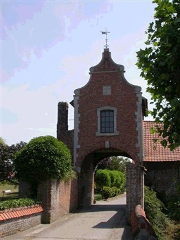
The Diesvelthoeve is a farm in the Belgian village of Otegem. Until 1813 this was the castle "in Diesvelt". The farm is today known as the Diesvelthoeve but also as the Diesvelt manor. Nowadays it is a walled farmstead, of which only the monumental entrance gate remains, together with a few bluestone columns located in the basement of the farm.
- Category
- Forgotten History
- Location
- Aalter, Belgium
- Coordinates
- 50.81725, 3.41206
- How to get there
- Google MapsApple MapsOpenStreetMap
- Wikidata
- Q5591838
What is Diesvelthoeve?
Diesvelthoeve is a Forgotten History place on VeroMaps. Other places close by: Kasteel Banhout, Landergemmolen, Bergmolen, Tiegem, Watertoren (Zwevegem Paul Ferrardstraat).
Where is Diesvelthoeve?
Diesvelthoeve is in Aalter, Belgium. Coordinates: 50.81725, 3.41206.
How do I get to Diesvelthoeve?
Diesvelthoeve is at Aalter, Belgium (50.81725, 3.41206). Enter these coordinates in Google Maps, Apple Maps or OpenStreetMap for walking, cycling or driving directions.