Forgotten History
Château de Montjardin
Henumont, Belgium
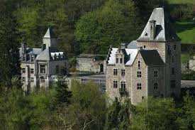
Montjardin Castle is a castle located in the Belgian town of Remouchamps (municipality of Aywaille). The first castle, of which only ruins can now be seen, is located between the villages of Remouchamps and Aywaille, in the locality of Dieupart. In the 12th century, a watchtower was built slightly above the Amblève river, and the tower was expanded into a castle over the centuries. The castle was especially remodeled in the 16th century and at the end of the 19th century.
- Category
- Forgotten History
- Location
- Henumont, Belgium
- Coordinates
- 50.47620, 5.71107
- How to get there
- Google MapsApple MapsOpenStreetMap
- Wikidata
- Q2970013
What is Château de Montjardin?
Château de Montjardin is a Forgotten History place on VeroMaps. Other places close by: Slope of Goats, Maison forte de Damré, Hautregard Castle, Château d'Amblève.
Where is Château de Montjardin?
Château de Montjardin is in Henumont, Belgium. Coordinates: 50.47620, 5.71107.
How do I get to Château de Montjardin?
Château de Montjardin is at Henumont, Belgium (50.47620, 5.71107). Enter these coordinates in Google Maps, Apple Maps or OpenStreetMap for walking, cycling or driving directions.