Forgotten History
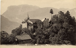
Château de Châtillon-sur-Cluses
Chatillon-sur-Cluses, France
The Château de Châtillon is a former fortified castle dating from the 12th century, with several later modifications. Its ruins are located in the commune of Châtillon-sur-Cluses, in the Haute-Savoie department of the Auvergne-Rhône-Alpes region.
- Category
- Forgotten History
- Location
- Chatillon-sur-Cluses, France
- Coordinates
- 46.08440, 6.58306
- How to get there
- Google MapsApple MapsOpenStreetMap
- Wikidata
- Q2968976
What is Château de Châtillon-sur-Cluses?
Château de Châtillon-sur-Cluses is a Forgotten History place on VeroMaps. Other places close by: Chapelle de Flerier, Pont Vieux de Cluses, Chapelle Saint-Grat de Mieussy, Chapelle de Jacquicourt.
Where is Château de Châtillon-sur-Cluses?
Château de Châtillon-sur-Cluses is in Chatillon-sur-Cluses, France. Coordinates: 46.08440, 6.58306.
How do I get to Château de Châtillon-sur-Cluses?
Château de Châtillon-sur-Cluses is at Chatillon-sur-Cluses, France (46.08440, 6.58306). Enter these coordinates in Google Maps, Apple Maps or OpenStreetMap for walking, cycling or driving directions.